

Roadbooks, Tulips & Tripmeters
A practical guide to reading, Understanding and following roadbooks on Touring Assemblies
Introduction
A roadbook can look slightly intimidating the first time you see one.
There may be instructions, strange little diagrams, numbers, arrows, symbols and distances that appear to make very little sense.
The good news is that roadbooks and navigation is much simpler than it first appears.
Once you understand the basic principles, the navigational side of roadbook becomes a very effective way of following a route without relying on conventional turn-by-turn sat-nav instructions.
This guide explains the fundamentals of roadbooks, how to read tulip diagrams, how distances work, how tripmeters can help, and how modern digital devices and apps can be used alongside traditional paper navigation.
The aim isn’t to turn you into a rally navigator overnight. It’s to give you enough understanding and confidence to pick up a roadbook and know what you’re looking at.
1. What is a Roadbook?
A roadbook is a set of instructions describing a route and the information needed to complete a touring assembly or rally.
Instead of simply telling you:
> Turn left onto the B3212.
a roadbook can show you a diagram of the junction, the distance from your previous instruction and additional information to help you identify the correct point.
Roadbooks have been used extensively in rallying and other forms of motoring navigation for decades. Tulip-style navigation is particularly associated with rally navigation and uses simplified diagrams to show the junction or route feature ahead. (Rally Navigator)
A roadbook isn’t intended to be a detailed map.
It is a navigational aid.
2. The Navigator
Roadbook navigation on a Touring Assembly is often a two-person job.
The driver should concentrate on:
● The road.
● Traffic.
● Speed.
● Hazards.
● Junctions.
● Other road users.
The navigator should concentrate on:
● Roadbook.
● Distances.
● Tulips.
● Upcoming instructions.
● Confirming the route.
The navigator can call instructions such as:
“Right in 300 yards.”
Then:
“Right at the T-junction.”
This allows the driver to concentrate on driving rather than trying to read a roadbook while moving.
3. The Front Page and information pages of a Roadbook
Before you start looking at tulip diagrams, distances and navigation instructions, take a moment to look at the front pages of the roadbook.
Think of this as the roadbook’s information and briefing pages.
A professionally produced rally-style roadbook will normally identify what the document is for, what route or section it covers and, depending on the event, provide important information about the route, distances, fuel requirements and safety. Many touring assembly style roadbooks show points of interest, optional refreshment stops, toilets etc.
The exact layout varies between organisers and types of event, but the principle is the same.
The front pages may include:
● Event name.
● Date.
● Start location.
● Finish location.
● Overall route distance.
● Distance units.
● Roadbook version or revision number.
● Controls or checkpoints.
● Important warnings.
● General navigation notes.
● Fuel range or refuelling information.
● Emergency or organiser contact
4. Navigational layout of Roadbooks
A typical navigational part of a roadbook might contain these columns:
|Total|Interval|Tulip|Sign|Info|
|-----|-------:|-——|-----|-----|
The exact layout varies between roadbooks, but Total and Interval are common ways of expressing distance. Historic UK tulip roadbooks also used interval and total mileage columns. (WSSCC Rally)
5. Total Distance
Total is the distance from the start of the route.
For example:
“Total: 4.25 miles”
means you should be approximately 4.25 miles from the point at which the route distance started
This is particularly useful for checking where you are on the overall route.
6. Interval Distance
Interval is the distance from the previous instruction.
For example:
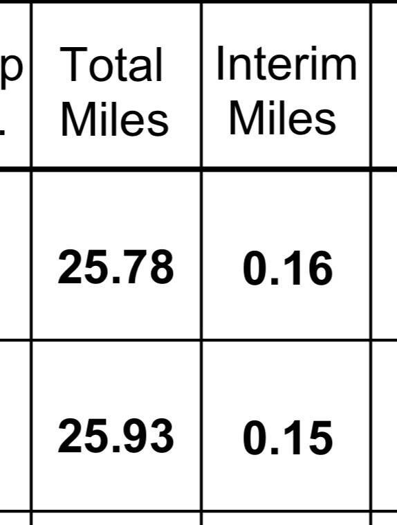
The next junction should therefore be approximately “0.15” miles away.
Once you understand this, interval distance becomes one of your best tools for anticipating what is coming next.
7. Distances Are a Guide — Not a Force Field
This is worth emphasising.
If your roadbook says:
“0.50 miles — Right”
and your tripmeter says 0.55 miles, that does not automatically mean you have missed the junction.
There can be differences caused by:
● Vehicle odometer accuracy.
● Tyre size.
● Tyre pressures.
● GPS accuracy.
● The route being measured differently.
● Where exactly the organiser measured the junction.
● Small differences in the line you drive through bends.
● Calibration of your tripmeter.
The roadbook distance should therefore be considered alongside the shape of the junction (tulip) and surrounding clues.
8. What Does a Tulip Actually Show?
A tulip is a simplified drawing of the road layout at a navigation point.
It isn’t supposed to reproduce every bend, hedge, building and road in the surrounding area.
Instead, it shows the information you need to make the decision.
Typically you will see:
● A dot showing your approach.
● Lines representing roads.
● An arrow showing the route you should take.
● Additional symbols or text where useful.
The dot-to-arrow principle is commonly used in tulip roadbooks: approach from the dot and leave in the direction of the arrow. (WSSCC Rally)
9. The Golden Rule of Tulip Diagrams
The single most important thing to remember is:
You approach the tulip from the bottom.
Imagine that the diagram is a little box representing the junction in front of you.
You are travelling up the page.
Your approach road normally enters the tulip from approximately the 6 o’clock position.
The road you need to take is indicated by the arrow.
This means you don’t need to rotate the diagram in your head.
You simply ask:
“Where am I entering, and which road does the arrow tell me to take?”
This approach is widely used in tulip-style roadbooks. (globalrally.co.uk)
10.Reading Your First Tulip
Let’s start with the easiest example.
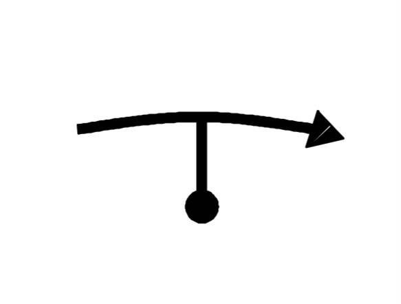
Imagine you approach the junction from the bottom.
The road ends at a T-junction.
The arrow points right.
Therefore:
Turn right.
That’s it.
You don’t need to know the name of the road.
You don’t need to identify every road shown on the diagram.
You simply follow the route represented by the tulip.
11. Left and Right Turns
The same principle applies to ordinary turns.
Left turn
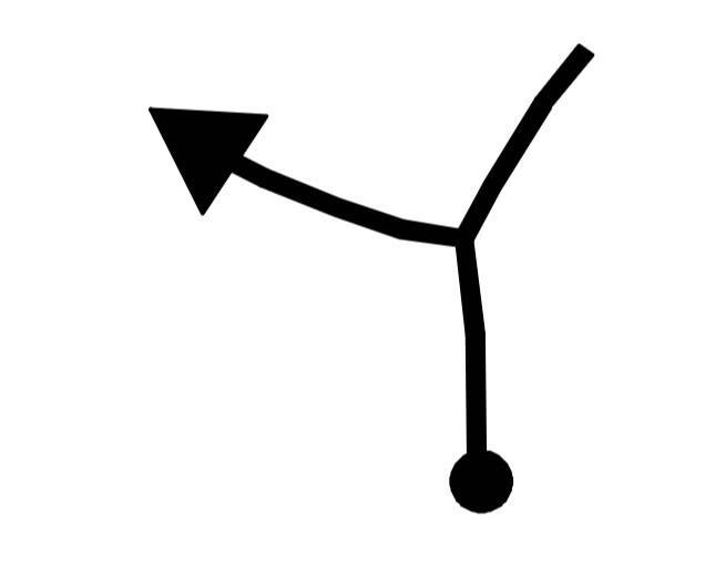
Approach from the bottom.
The arrow exits to the left.
Action: Turn left.
Right turn
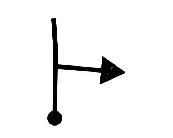
Approach from the bottom.
The arrow exits to the right.
Action: Turn right.
12. Going Straight Ahead
Not every junction requires a turn.
You may encounter a crossroads or junction where the route continues ahead.

The important point is that the diagram shows the junction and confirms which road you should use.
If there are several possible roads, the tulip helps distinguish the correct one.
13. T-Junctions
T-junctions are particularly easy to understand with tulips.
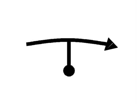
You approach from the bottom.
The road ahead ends.
The arrow tells you whether to turn left or right.
Remember:
The diagram is describing the junction from your point of view as you approach it.
14. Y-Junctions and Forks
A Y-junction can be more confusing because both roads may appear to continue ahead.
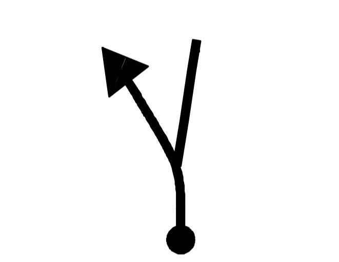
The arrow tells you which branch to take.
This is one of the situations where a tulip can be much clearer than a written instruction such as:
“Keep left at fork.”
15. Roundabouts
Roundabouts can be represented using tulip diagrams too.
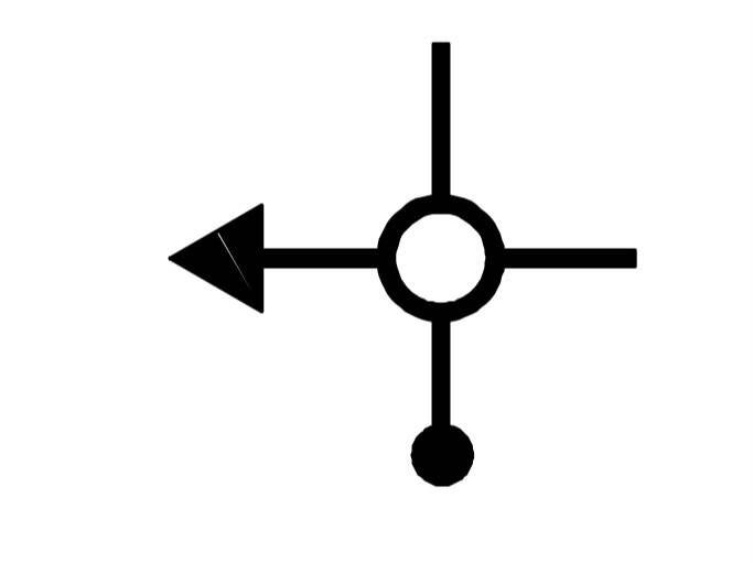
The diagram shows the roundabout and the required exit.
The roadbook may also include an exit number or additional information.
For example:
“Second exit”
would mean you enter the roundabout, continue around it and take the second available exit.
Important
Roadbooks are a navigation aid, not a replacement for normal road signs or road rules.
Always approach roundabouts, junctions and other hazards at an appropriate speed.
16. The Diagram Doesn’t Need to Look Like the Real Junction
This is an important point for beginners.
A tulip is schematic.
It doesn’t have to look like a photograph of the junction.
The purpose is to make the navigation decision obvious.
The two don’t need to look identical.
You are looking for the relationship between the roads, not an exact drawing of the landscape.
17. Using Distance and the Tulip Together
This is the real secret to successful roadbook navigation.
Don’t think:
“Distance OR tulip.”
Think:
“Distance + tulip + surroundings.”
For example:
“0.82 miles — Right at T-junction”
You are approaching 0.82 miles.
You’re looking for:
1. The approximate distance.
2. A T-junction.
3. A road going right.
4. A junction that resembles the tulip.
When all four agree, you can be confident you’ve found the correct instruction.
Let’s take some time out to discuss:
18. Tripmeters — Your Distance Companion
A tripmeter measures distance independently from your vehicle’s main odometer and can be reset during a route.
Traditional rally tripmeters have been mechanical or electronically driven, while modern units can provide highly accurate digital distance measurements and additional functions.
A tripmeter can be particularly useful because you can reset it at the start of the route and use it to monitor the distance between roadbook instructions.
19. The Old-School Tripmeter
Before digital GPS-based equipment became commonplace, competitors used mechanical and electromechanical tripmeters.
These could be mounted within the dashboard or on the navigator’s side.
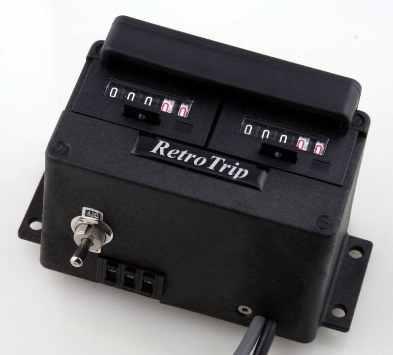
A traditional tripmeter might have:
● A reset mechanism.
● A running distance display.
● Mechanical digits.
● A connection to the vehicle’s speedometer drive.
Some rally cars also used more sophisticated equipment capable of being adjusted while travelling.
Why were they useful?
Because rally navigation often depends on knowing:
“How far have we travelled since the last instruction?”
20. Digital Tripmeters
Modern digital tripmeters make distance management much easier.
Depending on the model, they may offer:
● Resettable distance.
● Separate total and partial distances.
● Fine distance adjustment.
● Speed display.
● Average speed.
● Direction or heading.
● Multiple counters.
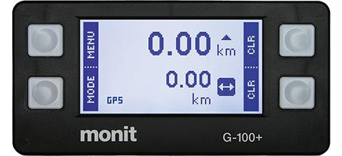
For a Touring Assembly, don’t become obsessed with chasing the last hundredth of a mile.
The objective is to have a useful and consistent indication of where you are on the route. Therefore the next section is the common tool on modern touring assemblies. Ask yourself:
21. Can I Use My Phone?
Yes.
A smartphone can be a useful navigation aid and can provide GPS-based distance information. Rally Tripmeter
There are now roadbook-style applications that can display tulips, distances, headings and other navigation information digitally. Some systems can load PDF, GPX or OpenRally roadbooks and provide a live digital roadbook display. (DMD Navigation Docs)
A phone can therefore be useful for:
● GPS distance.
● Mapping.
● Route tracking.
● Digital roadbooks.
● Recording your route.
● Backup navigation.
22. But GPS Isn’t Magic
GPS distance isn’t necessarily identical to the distance measured by a traditional vehicle-based tripmeter.
GPS can be affected by:
● Position accuracy.
● Signal quality.
● Sampling rate.
● Buildings.
● Trees.
● Valleys.
● Changes in direction.
● Software calculations.
This is particularly relevant on narrow, twisty roads.
Touring Assembly tip
Use technology as an aid.
Don’t let the technology distract you from actually driving the road.
Now back to the Roadbook….
23. Road Signs Still Matter
A roadbook does not override the road environment.
You must still obey:
● Speed limits.
● Give Way signs.
● Stop signs.
● Traffic lights.
● Temporary restrictions.
● Road closures.
● One-way systems.
● Other legal requirements.
Historic rally roadbooks have explicitly reminded competitors that road signs and speed limits must still be observed on public roads. (WSSCC Rally)
Many Touring Assembly and classic tours organisers include important sign information in there Roadbooks, like tulips these signs are marked by interval distance.
A Touring Assembly is about enjoying the roads, not competing with them.
24. Information Columns
A roadbook may contain more than just tulips distances and signs.
You might see a column for:
Information
landmarks and additional instruction or anything else the organiser wants the crew to know.
Different organisers use different layouts, so don’t assume every roadbook will look identical.
25. What Happens When the Roadbook and Reality Don’t Match?
This can happen.
A road may have been closed.
A sign may have disappeared.
Roadworks may have altered the layout.
Or you may simply have misread the instruction.
Don’t panic.
Slow down.
Find somewhere safe to stop if necessary.
Check:
● Your last confirmed position.
● Your last roadbook instruction.
● Your distance.
● The direction you travelled.
● The next instruction.
Then work out where you are.
Never make an unsafe manoeuvre simply to get back onto the route.
Traffic laws, road signs and safety always take priority over the roadbook.
26. What If You Get Lost?
Getting lost is not a disaster.
It happens.
The worst response is usually to panic and start making random turns.
Instead:
STOP
Find somewhere safe to stop.
THINK
Where were you definitely on the route?
CHECK
Look at the last roadbook instruction you know you completed.
REJOIN
Work out a safe way to return to the route.
27. Reading Ahead
Don’t wait until you’re sitting at the junction before looking at the next instruction.
A good navigator is already thinking about what comes next.
For example:
“0.40 — Left”
followed by:
“0.15 — Right”
You know that immediately after making the first turn, another decision is coming.
This prevents the classic:
“LEFT… LEFT… WAIT, RIGHT!”
moment.
28. Try Reading your Roadbook Before Driving
One of the best ways to learn is to read your roadbook while stationary.
Take your route and ask:
“If I were driving this now, what would I expect to see?”
This teaches you to associate:
Roadbook → Tulip → Real junction
Once you’ve done that several times, the system starts to feel natural.
29. The Touring Assembly Quick Reference
Before setting off
● Check the roadbook.
● Check whether distances are miles or kilometres.
● Check your tripmeter.
● Check calibration if required.
● Make sure the navigator understands the layout.
● Secure your roadbook and equipment.
● Make sure phones and other devices are safely mounted.
● Have a backup navigation method available.
At each instruction
● Check the distance.
● Read the tulip.
● Identify the junction.
● Confirm the direction.
● Make the turn safely.
● Confirm you’re on the correct road.
● Start preparing for the next instruction.
If something doesn’t look right
● Slow down.
● Don’t guess.
● Check the distance.
● Check the tulip.
● Look for the expected road layout.
● Stop somewhere safe if necessary.
30. Roadbook Navigation Isn’t About Speed
This is perhaps the most important message in the entire guide.
You don’t need to be a rally driver.
You don’t need an expensive competition car.
You don’t need a £1,000 navigation system.
And you certainly don’t need to drive quickly.
Roadbook navigation is about observation, communication and enjoying the journey.
A well-written roadbook can turn an ordinary drive into a small adventure.
You start with:
“Where am I going?”
and gradually progress to:
“I know exactly what I’m looking for.”
That’s when roadbook navigation becomes fun.
31. Final Thoughts
Roadbooks can initially look complicated because they use a language of their own.
But that language is remarkably simple once you break it down.
A dot.
An arrow.
A distance.
A junction.
A direction.
And, most importantly, a driver and navigator working together.
Start with simple routes.
Practise reading tulips while stationary.
Use a basic tripmeter or suitable phone based app alternative.
Don’t worry if your first attempt isn’t perfect.
And remember that technology is there to assist you — not to replace observation and common sense.
The best roadbook is one that lets you enjoy the road rather than constantly wondering where you are.
Read the road. Read the book. Enjoy the journey.
The Touring Assembly
Grassroots, non-competitive rally adventures